Tuesday, May 30, 2006

Southwestern Colorado

Sunday, May 28th

Molly and I went to Durango this weekend to visit Sandy and Doug, and my parents. We were looking for a nice ~8 mile run, and we weren't dissappointed. We ran the southern end of the Colorado Trail, from Junction Creek to Gudy's Rest. The first book we had, Hiking Trail of Southwestern Colorado, said the distance was 8 miles (round trip) , with ~1,000 feet of elevation gain. The other book, Trail Runners Guide to Colorado, said it was 5 miles (round trip) with ~1,500 feet of elevation. Hmmm, only one way to find out...

The run was awesome - about 2 1/2 miles of rolling/uphill along the river, then another 1 - 1 1/2 miles of switchbacks to Gudy's Rest. I think the first book was close to being right on the distance - it took us ~ 55 minutes to the top. We enjoyed the views on top for a few minutes, and the return trip took just over 40 minutes for a total time of 1:42. I thought it was one of the best runs we've done so far. Molly was really pushing me on the way up - I think she only stopped once on the switchbacks, while I had to stop 2 or 3 times.

Wednesday, May 24, 2006

Hills

Wednesday, May 24th

I'm starting to like the treadmill. I never thought I actually would say that - but there are lots of benefits. It's a very forgiving surface, I can control the speed and incline exactly, and a full workout lasts the same time as a full episode of Law & Order (TNT primetime in the daytime!!).

Today I did intervals of hills. 1 minute flat, 1 minute hill - constant speed of 12:00min/mile, and hills were an incline of 6%. My heart rate was ~145-150 at the top of the hills, and 125-30 at the beginning of them.

Speed Work

Monday, May 22nd

I don't run fast. I used to be fast - in elementary school I was always in the fastest group for track and field, and could break 2:00 in the 600 yd run. That was 20 years ago. Now, I'm slow. To remedy the situation, I'm trying some speed work. OK - it should probably be called "trying to jog faster than normal" work - I don't think speed is the appropriate term. Anyways, I think it's important, see this article by Buzz Burrell - one of the all time trail running legends.

I warmed up for 10 minutes, and then did quarter-mile repeats with 2 minute rests at the following speeds (mins/mile)

8:30, 8:00, 7:30, 8:00, 8:30, 8:45

As I said, I'm not fast. At this point, my right shin started to hurt - it's kind of a nagging injury. Anyways, it felt good to run faster, even if it was only for ~ 1.5 miles.

First Flatiron Loop


Sunday, May 21st

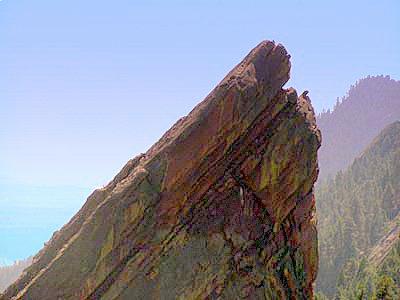
Went for a nice hike with Sandy. Doug rode his bike from Chautauqua to Nederland, and Molly already ran a 10K as part of the Colfax Marathon that morning - so it was just the two of us. We went up between the first and second flatirons, and then hooked up with the Saddle Rock trail back down Gregory Canyon. It's a beautiful hike - with a unique perspective of all 3 flatirons, including an awesome view of the North Face of the 3rd (pictured).

Monday, May 22, 2006

Matthews-Winters + Hogsback

Saturday - May 20th

Ran with Jenn, Conrad, and their friend Dave G. We decided to do the loop in the clockwise direction - starting with the hogsback. It seemed like a good idea at the time - but running down the hogsback is very technical (read: slow), and the slog back up the red rocks trail was just that - a slog. We started at ~8:30 - and I think we were all over-heated near the end. Time to either start earlier, or go to the high country.

Approximate Times:
Hogsback (2.2 miles): 33:00
Red Rocks Trail (2.7 miles): 38:15
Morrison Slide Junction: (3.9 miles): 59:00
Finish: (5.8 miles): 1:19:00

We clearly have a lot of work to do to get under 1 hour.

Wednesday, May 17, 2006

Green Mountain - Round 2

Tuesday, May 16th

Went back to do the Green Mountain loop again after work. Conditions were nearly perfect - the trails had completely dried out from last week, and there was no snow or mud anywhere on the trail. However, this only proved that my route finding problems last week weren't a result of the snow - I'm just an idiot. I probably took almost the exact same route up the last ~600 feet of Green Mountain - I thought I was on the trail, but clearly I missed it. I really wanted to get to the top in under 1hr, but I guess it wasn't meant to be. The run down was painful at times, and I had to walk just before the Mallory cave cutoff, until after crossing the creek and up the steep stairs. Total time was 2:10:51

Total Mileage: ~8.2
Total Elevation: ~2600ft

Here are my approximate splits (Note - this time I started from the trashcan closer to the top of the parking lot). Previous splits are in parentheses.

Amphitheater Trail: 7:10 (7:00)
Greenman Trail: 38:15 (41:00)
Green Mtn. Summit 1:03:35 (1:11:00)
Bear Peak W. Ridge 1:18:00 (1:29:00)
Mesa Trail 1:42:00 (1:58:00)
Finish: 2:10:51 (2:32)

Monday, May 15, 2006

Matthews-Winters

Friday - May 12th

Went out to [pdf] Matthews/Winters after work. I've probably been there half a dozen times this year and it doesn't get any easier. I ran the Red Rocks trail to the Morrison Slide Trail (the trail that goes onto the plateau). There are about 7 switchbacks up the hill, and even though I was able to jog them all last time, this time I only made it to the 4th one. From there I continued south on the Red Rocks trail down to the highway. I was just about to the highway when I took a nasty fall, and scraped up both knees and palms. ouch! Luckily no one was around to witness me sprawled out on the ground. I did the first half mile of Dakota Ridge, then jogged the highway back to the parking lot.

Approximate Splits (with total mileage):
Red Rocks Trail (1.1 miles): 12:30
Morrison Slide Trail (2.3 miles): 32:30
Red Rocks Trail (3.5 miles): 44:30
First part - Dakota Ridge (4.0 miles): 52:00
Parking lot (5.5 miles): 1:15:00.

Wednesday, May 10, 2006

Triple Crown


Wednesday - May 10th - 2006

After a pathetic attempt at the Big Bluestem loop on Sunday, I was anxious to get out again. I've had my eye on the "Triple Crown" - Green Mountain, Bear Peak, and South Boulder Peak for awhile. These peaks tower the flatirons, and I figured a linkup would be pretty cool. My plan was to climb Green Mountain via Saddle Rock/Greenman, then hook up with the West Ridge of Bear Peak, climb South Boulder Peak, then descend Shadow Canyon and run the Mesa trail back to Chautauqua Park. The city of Boulder has a nice map of these trails.

I watched the weather forecast Tuesday night, and they were calling for overnight snow above 9500 feet, and possible rain at lower elevations. I figured that was OK, since South Boulder Peak is the highest of the 3, and tops out at ~8500 ft. However, on my drive to Boulder I could see snow on Coal Creek golf course (louisville), and it looked like the flatirons also got a light dusting. oh well - not the end of the world.

When I got to Chautauqua, it looked like it had snowed about 1/2 - 1". The trails looked clear, so I figured it wouldn't be that big of a deal. I was wearing shorts, running shoes, and a long-sleeved capilene t-shirt. I started at about 7:30, jogged the baseline trail, and started up the amphitheatre trail to Saddle Rock. Snow was already starting to melt off the trees, and it felt like it was actually raining. very surreal. I forgot how steep (read: painful) the amphitheatre trail is, and I couldn't run very far up it. Even "power hiking" would be too generous of a term. At this point, I just wanted to keep moving, and get my heart rate below 200. The trail was wet and snow-covered in some points, but didn't cause any problems - I made it to the Greenman trail after about 40 minutes. I've been up this way before, and I've also gotten lost a couple of times - so I was a little nervous. For the last 600-700 vertical feet the mountain was completely covered in about 1.5" of snow - and I quickly lost the trail. bushwacking wasn't particularly difficult, but it did cost me some time. I reached the summit blocks in exactly 1:11 - nearly 10 minutes off my previous fastest time. I spent about a minute on the summit - it was a gorgeous day - no wind, no clouds, and the view of the Indian Peaks was spectacular.

I started down the west ridge of Green Mountain, then turned south towards Bear peak. the trail was snow covered - it was easy to run on, but I did manage to lose the trail a few times. After about 15 minutes I came to the trail for the West Ridge of Bear Peak and I stopped to consider my options. I'd never been on the West Ridge of Bear Peak before, and after my route-finding problems on Green Mountain, I figured I'd have more trouble ahead. I didn't really want to end up spending 2 more hours bushwacking (I told work I'd be online by noon), so I decided to head down Bear Canyon, and out to the Mesa trail. It was a great run down - so much better than running down either Gregory Canyon or Saddle Rock because it's not very steep and there aren't many rocks. Plus, the area to the west and south of Green Mountain is just an awesome place. Great views of the north face of Bear Peak and South Boulder Peak, and it's never crowded (especially on a weekend after it snows!). The trail was a little damp, especially towards the bottom, but not bad.

Parts of the mesa trail were borderline miserable, especially around NCAR. The trail was all mud, and I made faster progress by walking. I ran the last 1.5 miles, and just missed finishing in under 2:30 - hopefully I'll break that next time.

Total Mileage: ~8.2
Total Elevation: ~2600ft

Here are my approximate splits:

Amphitheater Trail: 7:00
Greenman Trail: 41:00
Green Mtn. Summit 1:11:00
Bear Peak W. Ridge 1:29:00
Mesa Trail 1:58:00
Finish: 2:32

the blue lines/arrows show my route, with the red lines/arrows indicating the route for all 3 peaks.